The words ŌĆ£common high tideŌĆØ, ŌĆ£common marineŌĆØ or simply ŌĆ£commonŌĆØ indicated the height that must be referred to, for example, when setting the foundations of a building six feet (about 210 centimeters) ŌĆ£below the commonŌĆØ, dredging the bed of a canal five feet (about 175 centimeters) ŌĆ£below the commonŌĆØ or establishing the upper edge of the embankments at two feet (about 70 centimeters) ŌĆ£above the commonŌĆØ. A reference of this importance was entrusted for centuries to the action of the water and the sunlight that made this sign, indistinct and imprecise by nature, variable and generally incoherent not only from one area of the city to another, but even across the two opposite sides of the same canal.
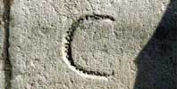
Towards the end of the seventeenth century, the Magistrati al Piovego established that the marine common would be indelibly set by a horizontal line with a capital ŌĆ£CŌĆØ above it, engraved on the stone of the embankment.
The attempt to give a univocal value to the height of the marine common was unsuccessful however, at least as far as we are led to deduce by current measurements, which show a persistent and significant reciprocal discordance among the marks that have been found. A similar lack of homogeneity cannot be reasonably attributed just to the scarce accuracy used to identify and mark these signs; there are in fact evident traces of later tampering that completely changed the surface of reference.
Throughout the historic city center, 111 signs have been found and measured. The data they supply shows that todayŌĆÖs level of reference (the tide-level-zero at the Punta della Salute) stands at a level of 40-45 centimeters below the marine common of the eighteenth century. Given that the current upper edge of the green strip on the canal embankments is 75-80 centimeters above the tide-level-zero, it may be said, with due approximation, that in little more than two centuries the level of the waters, in relation to the height of the embankment structures, has risen 30-40 centimeters.